| To Perrys Lookdown | ||
 |
||
| < To Highway | ||
| To Blue Gum Forest | ||
| Govetts Leap Rd | and Grose River | |
| Information Centre | ||
| < To Highway | ||
| < To Highway | ||
Maps of the Blue Mountains, Australia
New South Wales (NSW), Australia
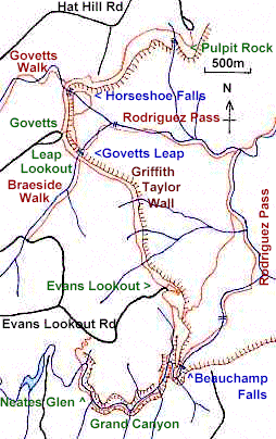
Bushwalking in the Grand Canyon - Govetts Leap area.
Related pages: Activities | National Parks | Tourist info
These maps are provided as a rough guide only.
Official maps and guide books are available from information
centres, bushwalking equipment shops, and some newsagents.
These tracks are not suitable for bicycles.
Excersise care when walking near cliffs! Edges can give way!
Cliff height exceeds 200m
Walks which descend below the cliff-top necessitate climbing down, and up, hundreds of
steps. Rodriguez Pass involves a 610m descent and ascent. You need to be fit!
Know your capabilities, know your route, check with
Information offices.
Always carry drinking water!
Carry warm, waterproof clothing; weather may change suddenly.
Observe signs, and stay on the track.
Wear sensible walking shoes, and a hat. Protect skin from the sun.
Carry a bag for rubbish; carry your rubbish out.
Map
Blackheath: Govetts Leap - Grand Canyon Area
| To Perrys Lookdown | ||
|
||
| < To Highway | ||
| To Blue Gum Forest | ||
| Govetts Leap Rd | and Grose River | |
| Information Centre | ||
| < To Highway | ||
| < To Highway | ||
![]()
![]()
![]() Plaza Entrance | B.M. Maps | Back to Top
Plaza Entrance | B.M. Maps | Back to Top
| Free Fonts | ||
| Used here | Host |
Blue Mountains Plaza, New South Wales (NSW), Australia
| This site
uses, & looks best with, free True Type fonts
, for PC and Mac, from
Microsoft. Copyright © 1996 David JW Martin except where other copyright applies. All rights reserved. Company, brand and product names are the property of their respective owners. Revised: June 26, 2003. |